
- Home
- About
- Earthquakes
- Public Relations
- Research
- Services
- Resources
- Contact

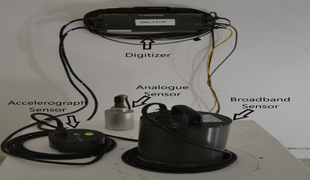
A standard seismic hazard map accounts for shaking when the substrate is uniform and consists of rock. When the substrate consists of unconsolidated soil or alluvium which may include clay, gravel and/or sand layers, seismic microzonation is necessary. Microzoning modifies a standard seismic hazard map by accounting for the varying levels of ground shaking that are brought about as the energy propagates through varying thickness and type of soil. This project to microzone Kingston is one module of UNESCO-IUGS-IGCP project 487: Microzonation of Latin American Cities. The modern methods of modal summation and 2-D finite-differences techniques will be used in conjunction with input information on the soil profile of Kingston and the seismicity of Jamaica to construct seismic hazard maps that are tailored for Kingston.
Our 7 faculties and 12 professional schools offer more than 200 programmes to some 18,000 graduate, undergraduate and continuing studies students.
The UWI, Mona ranks first in Jamaica among accredited tertiary-level programmes. In 2012, the University was again one of Jamaica’s Top 100 Employers.